__________________
Homeland Security
____________________
____________________


__________________
"The Storm Mountain Incident"
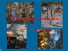
Pollution of our
National Forest Streams
(Requires
Free PowerPoint Viewer available here)
__________________

Contamination to Storm Mountain Properties
Click here for the facts!
__________________
__________________
![]()

![]()


__________________
![]()
__________________

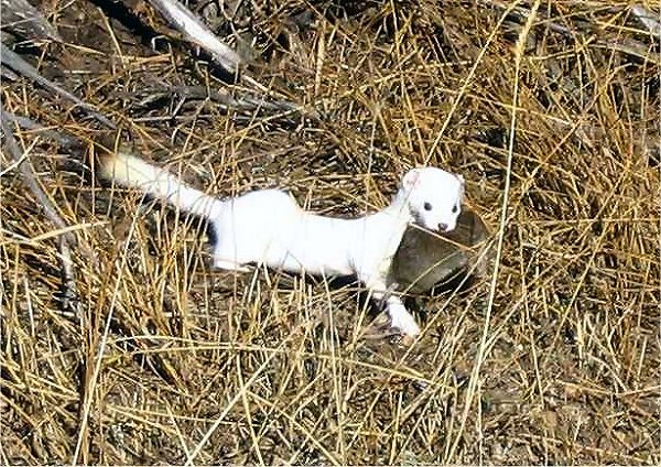
5AM Weather Update... Snow has stopped in the Storm Mountain area with Jupiter and the Moon currently being visible through the high clouds... Overnight accumulations of 2 to 4 inches are being reported with little to no further snow expected... Roads in the area, including FDR 128, are snow-packed with slick slushy spots... Residents are advised to allow plenty of extra travel time... Chains, adequate snow-tires and 4WD are highly recommended for travel on FDR 128... Winter Storm Warning Until 9AM... The National Weather Service in Denver has issued a Winter Storm Warning for the front range including the Drake, Glen Haven and Storm Mountain area effective until 9AM MST... QUICK HITTING SNOW STORM HITS THE FRONT RANGE... UPSLOPE WINDS BEHIND A COLD FRONT WILL PRODUCE A QUICK PERIOD OF HEAVY SNOW OVERNIGHT. SNOWFALL RATES OF 1 TO 3 INCHES PER HOUR CAN BE EXPECTED IN THE FOOTHILLS... THE SNOW WILL DIMINISH NEAR THE WYOMING BORDER IN THE EARLY MORNING HOURS, WHILE THE HEAVY SNOW WILL CONTINUE SOUTH OF INTERSTATE 70 UNTIL AT LEAST SUNRISE... Sunday, January 30th - Winter Weather Advisory Issued... The National Weather Service in Denver has issued a Winter Weather Advisory for the front range including the Drake, Glen Haven and Storm Mountain areas until 9AM Monday... A RAPIDLY MOVING STORM SYSTEM OVER WYOMING WILL DIVE SOUTH OVERNIGHT, BRINGING ANOTHER ROUND OF SNOW IN THE FOOTHILLS... THE SNOW WILL BECOME INCREASINGLY WIDESPREAD OVERNIGHT WITH 3 TO 6 INCHES OF SNOW ACCUMULATION POSSIBLE BY DAYBREAK MONDAY... THE HEAVIEST SNOW ACCUMULATION WILL BE OVER THE FOOTHILLS OF JEFFERSON COUNTY FROM EVERGREEN SOUTHWARD... THERE WILL AREAS OF DENSE FOG DEVELOPING TOWARD MORNING WITH VISIBILITIES EXPECTED TO BE BELOW A HALF MILE... TRAVEL WILL BE DIFFICULT OVERNIGHT AND EARLY MONDAY IN THE FOOTHILLS... Photo Of The Week... This week's photo is of a "Short-tailed Weasel" with it's winter coat carrying a catch of a field mouse, taken last week near Rocky Mountain National Park by Christine Podesva-Spangler... The Short-tailed Weasel, active day or night, may be fairly common at times but is seldom seen... Although it hunts mainly on the ground, often running on fallen logs, it can climb trees and occasionally pursues prey into water... This carnivore kills all that is available and stores the excess... Mice, particularly meadow voles, are its main food, but its diet also includes shrews, baby rabbits, birds, frogs, lizards, snakes, and many kinds of insects...
Saturday, January 29th - Winter Weather Advisory Issued... At 3:00PM, the National Weather Service in Denver issued a "Winter Weather Advisory" from 6PM this evening through 4PM Sunday for the Front Range foothills and mountains east of the Continental Divide... A PACIFIC STORM SYSTEM OVER THE DESERT SOUTHWEST WILL MOVE THROUGH NORTHERN ARIZONA TONIGHT AND INTO NORTHERN NEW MEXICO BY SUNDAY AFTERNOON... AS IT DOES SO, UPSLOPE CONDITIONS ARE EXPECTED DEVELOP ALONG THE FRONT RANGE TONIGHT AND CONTINUING INTO SUNDAY... TOTAL SNOWFALL WILL RANGE FROM 5 TO 10 INCHES IN THE MOUNTAINS EAST OF THE CONTINENTAL DIVIDE, SOUTH PARK AND IN THE FRONT RANGE FOOTHILLS, HEAVIEST FROM BOULDER COUNTY SOUTHWARD.... ALONG THE PALMER DIVIDE SOUTH OF DENVER, STORM TOTALS WILL RANGE FROM 4 TO 8 INCHES... A WINTER WEATHER ADVISORY MEANS THAT A COMBINATION OF SNOW, WIND AND COLD TEMPERATURES WILL CREATE DIFFICULT TRAVEL CONDITIONS... The complete text of this advisory can be found via the link below...
Winter Storm Watch Issued... The National Weather Service in Denver has issued a "Winter Storm Watch" in effect from this evening through Sunday afternoon for the northern foothills including the Drake, Glen Haven and Storm Mountain areas... A POTENT STORM SYSTEM OVER THE DESERT SOUTHWEST WILL SPREAD MOISTURE ACROSS COLORADO TODAY WITH UPSLOPE CONDITIONS DEVELOPING TONIGHT AND CONTINUING INTO SUNDAY... UP TO A FOOT OF SNOW WILL BE POSSIBLE BY SUNDAY AFTERNOON... THE HEAVIEST SNOW IS EXPECTED IN THE FOOTHILLS OF JEFFERSON, GILPIN, CLEAR CREEK AND BOULDER COUNTIES... The complete text of this watch can be found via the link below...
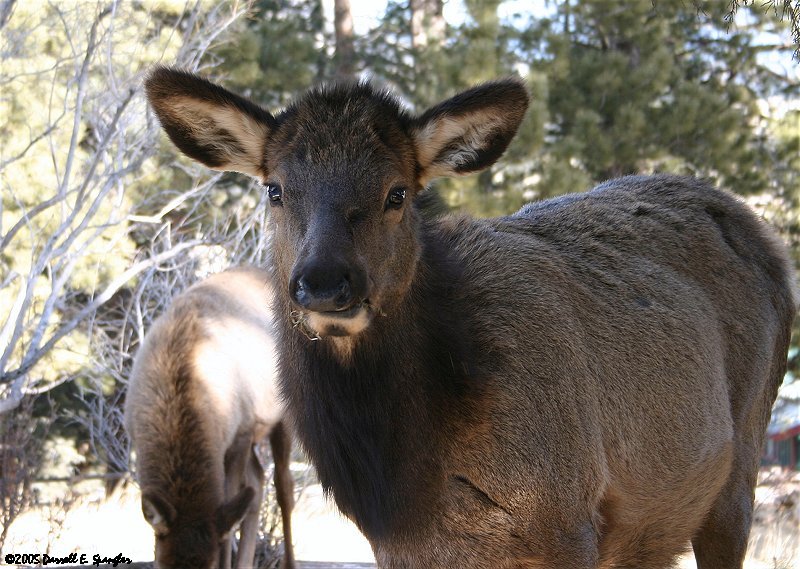
Friday, January 28th - Morning Fog Reported Throughout Valley... As of 5AM, dense fog is being reported in many areas below making the morning commute in the valley slow and hazardous... Hwy 36 from Boulder to Estes Park, Longmont, Loveland, and I-25 from Fort Collins to the Wyoming Border area reporting dense fog... Residents traveling to the valley today are advise to use caution and allow extra travel time... Monday, January 24th - Full "Wolf Moon" Tonight... Amid the cold and deep snows of midwinter, the wolf packs howled hungrily outside Indian villages... Thus, the name for January's full Moon, the "Wolf Moon"... Sometimes it was also referred to as the "Old Moon", or the "Moon After Yule"... Some called it the "Full Snow Moon", but most tribes applied that name to the next Moon... Full Moon names date back to Native Americans, of what is now the northern and eastern United States... The tribes kept track of the seasons by giving distinctive names to each recurring full Moon... Sunday, January 23rd - Photo Of The Week... This week's photo features a young Elk grazing in a homeowners yard on Aspen Avenue in Estes Park... Elk are plentiful in the town and it is not uncommon to see sights like these on you doorstep any given day...
Storm Mountain Net |
||||||

Disclaimer: Stories and other content are submitted by independent sources and do not represent the opinions or views of Storm Mountain Net, nor it's employees... All stories are posted without bias to their content... While every attempt is made to be concise in our reporting, Storm Mountain Net is not responsible for any incorrect information...