Storm Mountain News

News   |   Weather   |   Classifieds   |   Community   |   Editorial   |   Entertainment   |   Shopping   |   Archive


Storm Mountain News

Sorry, your browser doesn't support Java.

Local News


Listen to this article

Drake, Colorado - Then and Now

Drake, Colorado - Then and Now

Saturday December 30th - FLASHBACK: Monday July 31st - Big Thompson  Flood 30th Anniversary....

Today marks the 30th anniversary of the dreadful summer day when heavy afternoon rains sent a raging torrent of water down the Big Thompson Canyon killing 139 people, causing millions of dollars in damage and resulting in the worst natural disaster in Colorado history.

As people along the Big Thompson River fished and enjoyed what appeared a beautiful summer day, a stalled thunderstorm upstream was rapidly dropping months worth of rain in a few short hours. By evening, this rain would swell local streams feeding the Big Thompson, sending a 14 foot wall of devastation down the Big Thompson Canyon.
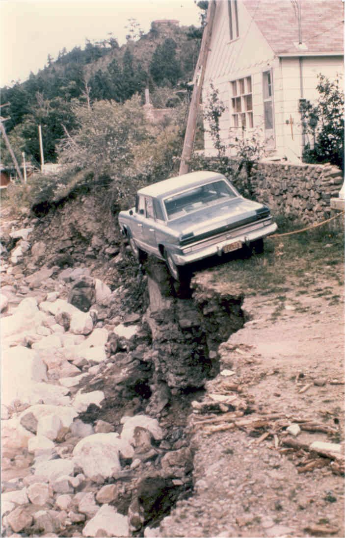
Homes were washed away along with the residents in them. Survivors speak of seeing the headlights of automobiles bobbing under the surface of the raging river, some with occupants still inside. Highway 34 was completely washed away in many places leaving motorists stranded on precarious outcrops dangerously close to the raging flood waters. By the end of the day, 139 people would have lost their lives in this mountain tragedy. The bodies of six others would never be found.

Cars hangs precariously on edge after floodDuring the initial stages of the flood a Colorado State Patrolman, Sergeant W. Hugh Purdy, and an Estes Park officer, Michel O. Conley, frantically traveled the dangerous roadways warning residents and visitors of the impending danger. Some reportedly laughed at the officers' warnings and were swept away in the flood. The officers themselves made the ultimate sacrifice, losing their own lives in their dedication to 
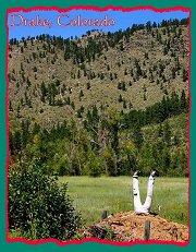
saving others. A memorial stands today in honor of these brave law enforcement officers whose selfless efforts saved many from certain death.

A "High-Water" marker will be dedicated today at the location of the old power plant which was washed away in the flood. Only the turbines remained. Memorials and remembrances are also scheduled at the Big Thompson Community Building, near the flood memorial markers along Highway 34, one mile east of Drake.

The Loveland Reporter-Herald is running an excellent series on the "1976 Big Thompson Flood", including several interactive online presentations. This superb documentation of the tragic event can be viewed by clicking the link below.


Other Big Thompson Flood Links

Fort Collins Coloradoan
Online Flood Presentation

1976 Big Thompson Flood Memorial

Big Thompson Canyon - Larimerco.com


Listen to this article

Winter Storm Warning...

Winter Storm Warning

Thursday, December 28th - Winter Storm Warning...

The National Weather Service in Denver has issued a Winter Storm Warning for the Front Range mountains and foothills, including the Drake, Glen Haven and Storm Mountain area, in effect from noon on Thursday through 6 AM MST Friday morning.

SNOW IS EXPECTED TO DEVELOP BY MID DAY THURSDAY AND QUICKLY BECOME HEAVY WITH SNOWFALL RATES UP TO 2 INCHES PER HOUR LATE THURSDAY AFTERNOON AND THURSDAY NIGHT. TOTAL ACCUMULATIONS BY EARLY FRIDAY MORNING ARE EXPECTED TO RANGE BETWEEN 1 AND 2 FEET ACROSS THE FRONT RANGE MOUNTAINS AND FOOTHILLS, WITH LOCALLY HEAVIER AMOUNTS UP TO 30 INCHES POSSIBLE IN THE FOOTHILLS OF BOULDER AND JEFFERSON COUNTIES. MORE ACCUMULATING SNOWFALL WILL BE POSSIBLE FRIDAY INTO SATURDAY. 

REMEMBER, A WINTER STORM WARNING MEANS HAZARDOUS WINTER WEATHER CONDITIONS ARE IMMINENT OR HIGHLY LIKELY. SIGNIFICANT SNOW ACCUMULATIONS ARE OCCURRING OR EXPECTED. THIS WILL MAKE TRAVEL VERY HAZARDOUS OR IMPOSSIBLE.

The brunt of this powerful storm is currently taking aim on our local area. Residents are advised to prepare for extreme winter conditions. Make sure you have plenty of food and water on hand as travel may become impossible by Friday. Residents are also advised to check on their neighbors, particularly the elderly, handicapped and/or ill. Pets and livestock should also be well stocked with food and water and checked periodically during the storm. 

Travel during the storm warning period is strongly discouraged. If you must travel, carry a "Winter Survival Kit" with you. If you get stranded, stay with your vehicle and wait for help to arrive.

The complete text of this official warning can be found via the link provided below.

Winter Storm Warning


Listen to this article

Winter Storm Watch...

Winter Storm Watch

Wednesday, December 27th - Winter Storm Watch...

The National Weather Service in Denver has issued a Winter Storm Watch for the Front Range mountains and foothills, including the Drake, Glen Haven and Storm Mountain area, in effect from Thursday afternoon through Friday morning.

A POTENT WINTER STORM WILL SPREAD POSSIBLE HEAVY SNOW ACCUMULATIONS ACROSS THE EASTERN SLOPES OF THE FRONT RANGE MOUNTAINS AND ADJACENT EASTERN FOOTHILLS, THE URBAN CORRIDOR,  AND THE NORTHEAST PLAINS OF COLORADO ON THURSDAY AND FRIDAY. 

THE STORM WILL PRODUCE STRONG AND GUSTY WINDS ALONG WITH AREAS OF BLOWING AND MUCH DRIFTING SNOW. MANY STREETS AND HIGHWAYS WILL AGAIN BECOME ICY AND SNOW PACKED. CHAINS OR ADEQUATE SNOW TIRES MAY BE REQUIRED ON HIGH MOUNTAIN PASSES. SNOW AND BLOWING SNOW MAY PRODUCE POOR VISIBILITIES AT TIMES OVER THE PLAINS AND ON HIGH MOUNTAIN PASSES. NEAR BLIZZARD CONDITIONS WILL BE POSSIBLE ON THE PLAINS AND PALMER DIVIDE. 

ALL DRIVERS ARE URGED TO EXERCISE CAUTION OR POSTPONE TRAVEL UNTIL WEATHER CONDITIONS IMPROVE. THE STORM MAY ALSO DELAY OR POSSIBLY PREVENT AIR TRAVEL FROM DENVER INTERNATIONAL AIRPORT. ALL HOLIDAY TRAVELERS SHOULD CHECK AIRLINE SCHEDULES FOR DELAYED OR CANCELED FLIGHTS.

The complete text of this official watch can be found via the link provided below.

Winter Storm Watch


Listen to this article

Wildfire On Storm Mountain

Wildfire on Storm Mountain

Tuesday, December 26th - FLASHBACK: March 4th - Wildfire On Storm Mountain...

A large, rapidly growing wildfire, now officially named the "Switchback Fire", is currently burning near Combat Rock on Storm Mountain. As of 12PM noon, the fire was estimated at 5 to 6 acres in size.

Residents and members of Storm Mountain Emergency Response Team (S.M.E.R.T.) have set up a line of volunteers near the top of the switchbacks. Air support is being called in to help battle the blaze. A Loveland (LRFP) fire crew is on scene and working a line along the right flank of the fire. A staging area has now officially been set up at the River Forks Stage Stop at the intersection of Hwy 34 and CO 43.

Loveland Rural Fire Protection was first on the sceneLarimer County Sheriff's have closed FDR 128 and are stopping residents from going up FDR 128 to release their animals or gather belongings, infuriating many local residents. Should the fire block this road, all residents would be trapped on the mountain as FDR 128 is the only access and egress to the area.

High and gusty winds are feeding the fire which is traveling to the North-Northeast up Bobcat Gulch. This blaze is taking an almost identical path as the "Bobcat Gulch Wildfire" which burned over 11,000 acres in 2000.

Flames climb through rocky terrain just before noon on SaturdayResidents are advised to prepare for possible evacuations in the Cedar Park and Cedar Springs area. Official fire info will be posted on this site as it becomes available.

UPDATE: As of 1:30pm air crews are dropping water on the blaze slowing the fire's progress. No evacuations have been ordered.

While no official cause has been noted, it is highly suspected to be a result of a campfire as youths were reported camping in that exact area last night.


Listen to this article

Horse runs through snow on Thursday

Horse runs through snow on Thursday

Sunday, December 24th - Photo Of The Week...

This week's photo of the week features a horse running through nearly three feet of snow early Thursday afternoon on Storm Mountain.

Last week's snowstorm dumped heavy snow across our area with accumulations ranging from 24 inches on Storm Mountain to a reported 52 inches in Glen Haven.

Many area roads are still snow-packed and icy. Some area residents are still unable to get out of their driveways due to deep drifts. 

Area residents are advised to use caution if traveling today, particularly on rural roads. 


Previous Week


Storm Mountain News Weather

Weather Info

Current Alerts

Nexrad Radar

Local Forecast

Road Conditions

Ski Conditions

School Closures

Wildfire Info

Fire Danger

Fire Weather

Burn Regulations


Google


Privacy Statement     Code of Ethics     Advertise     Contact Us

©2006 Storm Mountain News